Greenbank Rail Trail
Chester Road, Northwich, Cheshire, CW8 4AG

To build your own Itinerary, click to add an item to your Itinerary basket.
Already saved an Itinerary?


This walk takes you on a circular clockwise route around the outside of Hartford Campus into Clough Wood, following the banks of the River Weaver to the Boat Yard and then on through Marshall’s Arm Nature Reserve, following a footpath that includes a series of constructed wooden steps and bridges then returning past Hartford Parish Church. Download the rail trail leaflet here.
DISTANCE: 4 km
MAP: OS Explorer Map, sheet 267 scale 1: 25,000
GROUND CONDITIONS: The walk begins and ends with surfaced footpaths, but the main part of the walk is through a wooded copse on a footpath that is quite uneven and requires steps to be climbed. Walking boots or wellingtons are recommended as the path can be a bit muddy in places! STILES: None
KISSING GATES: None
ACCESS: This route is not accessible by wheelchair.
REFRESHMENTS: The Hart of Hartford, School Lane, Hartford
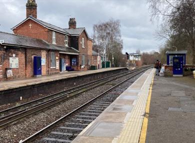
1. Starting from: Greenbank Station from the Manchester bound platform Leave the platform through the station building gate into the car park. The station building has been converted for use as ‘Christ Church Greenbank’, daughter church to St John’s Church at Hartford. Take the steps up to Chester Road and turn left so that you walk back across the railway bridge. Or Greenbank Station from the Chester bound platform Leave the platform and walk up the ramp towards the housing estate. Greenbank Rail Trail Route This walk takes you on a circular clockwise route around the outside of Hartford Campus into Clough Wood, following the banks of the River Weaver to the Boat Yard and then on through Marshall’s Arm Nature Reserve, following a footpath that includes a series of constructed wooden steps and bridges then returning past Hartford Parish Church.
2. Take the first turning left into Greenbank Lane and after a very short walk turn left into Marshall Lane (the turning is directly opposite the shops). Continue down Marshall Lane past the houses keeping to the left for some way. When you get to the green (where the road starts to bend to the right) you go left towards the cluster of blue signs at the end.
3. Follow the sign for “Cycle Route 5” and this will take you past Saxons Lane Play Area - keeping the football playing field on your right. At the junction (where you see houses on the left) turn sharp right and head down the tarmac path into Clough Wood.
4. Continue walking with Clough Wood on the right until you see the blue Boat Yard gates and then take the signposted footpath to “Marshall’s Arm” through the black entrance gates. This takes you into the popular Marshall’s Arm Nature Reserve.
5. Continue along this path for some way, following the sign in the direction of Hartford Blue Bridge. The Kingsmead Estate can be seen on the left, beyond the caravan graveyard!
6. The path then meets the banks of the River Weaver (the steps on the right lead up to the High School). A little further on there is a boat mooring platform and a bench; this is a nice place to stop and rest for a picnic or do a spot of birdwatching.
7. Walking on a little further you will pass a Notice Board with information for “Marshall’s Arm Local Nature Reserve” and the planned programme of events.
8. Continue until you come to the next signpost and then go right taking the path to Hartford Campus where you will see a flight of steps. Count the first 12 steps and then take the left-hand path, keeping the stream on your left. Continue, walking under the pipeline and then up a further set of 24 steps after which the path becomes a little more irregular.
9. At the top, go across the small wooden bridge and continue along the path and down 18 steps and over a further bridge across a small ravine, then wind onwards through the copse, crossing several more small gulleys.
10. After a longish stretch you will pass Hartford Manor Primary School on the right and housing on the left starts to come into view as you near the end of the trail. This is marked by a decorative entrance/exit iron gateway which was designed by students of Hartford High School.
11. The path ends at the junction with Stones Manor Lane, so turn left here and start walking up towards the houses and the play area just within sight.
12. At the end of Stones Manor Lane turn right into School Lane (unsigned). Where the road forks, turn right (this is a one way road with traffic coming towards you). Very soon you will see on your right the very welcome sight of the “The Hart of Hartford” coffee shop, bar and restaurant which has some tables and chairs outside too if you prefer to stay outdoors. It is open 7 days a week (see below) and has an excellent menu.
13. Continuing along School Lane you will pass the new Hartford Parish Church Hall completed in 2010 which is of interesting architectural design. In the background is the contrasting more traditional design of the Victorian Parish Church called St John's Church, Hartford.
14. School Lane then joins with Chester Road, turn right here and continue to walk for some distance along the footpath, past the Vets Surgery and the Sainsbury’s Local on the left until you reach Greenbank Station which will be on your right. If you’ve timed it perfectly, the train will be just pulling into the station for you to board for your return journey!
| 2024 (1 Jan 2024 - 31 Dec 2024) |
|---|
A unique aspect of Hartford is how child and family friendly the course is, it boasts…
Life could be very tough for the people of mid-Cheshire but never more so than for those…
Book one of our extended River Cruises along the picturesque Weaver Navigation (at 11…
We are extremely sorry to inform our customers that the Anderton Boat Lift structure will…
Enjoy a pleasant stroll around the lake, walk your dog or stop and watch the many…
Sandiway Golf Club was established in 1920. The very highly-rated 18-hole course is set…
Northwich Woodlands is a rich and green environment to the north of Northwich town centre…
At Marbury Country park you can wander along the mere with splendid views over the water…
Cheshire’s salt – the precious mineral on which this county sits – has been prized since…
Vale Royal Falconry is a new birds of prey and wildlife centre set in the beautiful…
Enjoy freshly-made ice cream with 18 different flavours.
Segway PTs are available for courses suitable for all pockets and time, corporate events…
Cheshire Outdoors brings together a huge range of outdoor activities to pack a fun filled…
An internationally reknowned centre: A visitor attraction for people interested in birds…
Anderton Nature Park is located next to the historic Victorian boat lift and close to…
Situated in the heart of Cheshire just outside Chester, Blakemere Village is home to a…
© Visit Chester. All Rights Reserved