Northwich Rail Trail 3km Walk
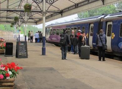
Northwich Railway Station, Manchester Road, Northwich, Cheshire, CW9 5LY
To build your own Itinerary, click  to add an item to your Itinerary basket.
Already saved an Itinerary?


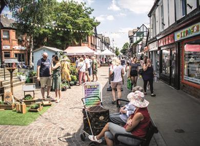
This is a short urban walk through parts of Northwich, whose history is dominated by the salt and chemical industries. The town has many distinctive black and white buildings. The Rivers Weaver and Dane converge in the town, the Weaver having been a busy commercial waterway. Within a short distance are the iconic Anderton Boat Lift and the Northwich Woodlands: more than 20 miles of paths serve a wide variety of habitats, including ancient woodland as well as park land, making it a suitable venue for families. Visit www.gonorthwich.co.uk for Your Complete Guide to Northwich
You can find full details including a map of the route which shows the places you will pass on page 20 of our Rail Walks in Cheshire West booklet
DISTANCE: 3 km
MAP: OS Explorer Map, sheet 267 scale 1: 25,000
GROUND CONDITIONS: This walk is all on pavements and footpaths and there are no stiles or other obstructions. Also the terrain is basically flat, with only a very minor climb over the railway bridge.
STILES: None
KISSING GATES: None
ACCESS: This route is suitable for all members of the family and also wheelchair use. The shorter version of the walk is about 1 ¾ miles (3 km) and the longer one adds about a further ⅓ mile (½ km). Allow ¾ hour for the basic walk without any stops at the points of interest and a further ¼ hour for the extension.
REFRESHMENTS: Available from Costa Coffee café in Tesco next to the station and between April and October in Vickersway Park (also known as Roker Park).
1. Leave Northwich Station from the Manchester bound platform. Keep left of the petrol station and leave the car park through the black bollards. On your left is a set of traffic lights. At these lights cross Middlewich Road and enter Victoria Road (the road sign can only be seen after you enter the road). Walk along Victoria Road until the end (approx ¼ mile).
2. At the end of the road, turn left into Vicarage Road and cross the railway bridge using the pavement on the right-hand side. Turn into the first road on the right, Manora Road. The railway line is on your right-hand side.
3. At the junction with Carlton Road on the left, walk straight ahead until Vickersway Park is seen also on the left. Enter by the first gate and the route keeps to the right, running parallel to the railway. There are various attractions in the park including an aviary and these may be visited with a very small deviation. It has a good range of facilities including a children’s play area, crazy golf, putting green, bowls, tennis courts, skatepark, a new aviary and an outdoor gym. Various objects of historical interest are on display including part of a 22 pillar from the local Vale Royal Abbey. The Abbey was founded in 1270 and closed in 1538 by Henry VIII, as part of the dissolution of the monasteries.
4. At the end of the park leave by the left hand pedestrian gate and continue in the same direction, with a skate park on your left and railway arches on your right, until you meet the River Dane. The distance from the start of Manora Road to this bridge is approximately ⅔ mile. At this point you have the option of taking a small extension to visit the Weaver Hall Museum.
5. To do the extension cross the footbridge in front of you and turn left under the viaduct into London Road and the museum is on your right in an imposing Victorian workhouse building. Its displays reflect the history of Mid Cheshire and the salt industry. The museum is open daily except Monday and offers light refreshments. When you have finished at the museum retrace the route until you have recrossed the footbridge.
6. To continue the walk now follow the line of the river with the footbridge behind you (the narrow path down to the river soon merges with the main route). Follow this path until you pass three metal figures behind a bench. These represent a salt worker, Paula Radcliffe and Gary Barlow.
7. Shortly after these figures, take the right fork that leads away from the river until you meet Whalley Road. Turn right and follow this until the road ends. Continue in the same direction with a school playground on your left. Continue along the path, when it turns sharp left and shortly before the tunnel under the railway, turn left through the gate into the cemetery of St Helens, Witton, also known as Northwich Parish Church (approx ½ mile). This is the most historical building in the town, founded in the 14th century. A Grade 1 listed building, it is included in Clifton-Taylor’s list of best English parish churches. Among its outstanding features are a Tudor roof and splendid Victorian stained glass windows.
8. Follow the tarmac path and exit onto Church Road, where there is a large war memorial on your left. On the opposite side of Church Road are two Victorian buildings. The left one opened in 1869 and was the third building to house Witton Grammar School for boys. The building to its right was the large master’s house built in 1878. The original school was founded in 1557 by Sir John Deane and the first and second buildings to house the school were in the churchyard near the gate you have just come through. Sir John Deane’s College is now on a nearby site off London Road, having recently benefitted from a £28 million redevelopment programme.
9. Cross over the road and into Victoria Road and follow this back to Middlewich Road and Northwich Station (approx ⅓ mile).
| Open Christmas |
|---|
| Open New Year |
|---|
| 2024 (1 Jan 2024 - 31 Dec 2024) |
|---|
© Visit Chester. All Rights Reserved